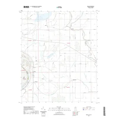
2020 Map of Beulah
USGS Topo · Published 2020About this map
Mississippi River waters define the western edge of this Bolivar County landscape, where the state boundary follows the shifting channel near Beulah Island Number 74 and the oxbow of Lake Beulah. The interior reflects a classic Delta agricultural pattern, with a grid of rural roads such as Old Malvina Rd and Beulah Rd connecting scattered communities and family burial grounds. Local history is anchored by the town of Beulah, alongside smaller clusters at Christmas, Mound City, and Symonds. The land is heavily intersected by a complex drainage network of bayous, including Laban Bayou, Dry Bayou, and the prominent Bogue Phalia to the east. Several cemeteries, such as New Hope Cem, Scotland Cem, and Waldon Cem, remain as primary genealogical markers within the plantation-style layout of the modern terrain.
Find a feature on this map
73 named features on this map. Tap any name to fly to it.
Don’t see what you’re looking for? This feature index may not catch every label — zoom into the map to look around manually.
Map Details
Editions of this 2020 Beulah Map
This is the sole edition of this map. No revisions or reprints were ever made.
Other maps of this area

1933 · Lamont
USGS Topo · 1:62,500

1939 · Pace
USGS Topo · 1:62,500

1939 · Big Island
USGS Topo · 1:62,500

1939 · Lamont
USGS Topo · 1:62,500

1939 · Choctaw
USGS Topo · 1:62,500

1953 · Greenwood
USGS Topo · 1:250,000

1956 · Greenwood
USGS Topo · 1:250,000
1967 · Skene
USGS Topo · 1:24,000

1967 · Lobdell
USGS Topo · 1:24,000
1969 · Choctaw
USGS Topo · 1:62,500