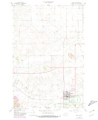
1968 Map of Beulah
USGS Topo · Published 1981About this map
Beulah sits at the confluence of the Knife River and Spring Creek, serving as a central hub for Mercer County's energy and agricultural activities during the late 1960s and 1970s. The landscape is defined by the industrial footprint of the Strip Mine to the northeast and numerous Gravel Pits scattered across the township. Transport and infrastructure are prominent, with the Burlington Northern railroad and the Beulah Airport facilitating movement through this prairie region. Notable for genealogists are the family-named Boeckel Cem and Sarah Cem, alongside the primary town Cem. The presence of an Old RR Grade south of town indicates an evolving rail network, while local culture is reflected in the Rodeo Grounds and Beulah Park near the riverbanks.
Find a feature on this map
17 named features on this map. Tap any name to fly to it.
Don’t see what you’re looking for? This feature index may not catch every label — zoom into the map to look around manually.
Map Details
Editions of this 1968 Beulah Map
2 editions found
Other maps of this area

1954 · McClusky
USGS Topo · 1:250,000

1958 · McClusky
USGS Topo · 1:250,000

1968 · Beulah
USGS Topo · 1:24,000

1968 · Medicine Butte NE
USGS Topo · 1:24,000

1968 · Red Butte NW
USGS Topo · 1:24,000

1968 · Hazen West
USGS Topo · 1:24,000

1968 · Medicine Butte
USGS Topo · 1:24,000

1969 · Beulah NE
USGS Topo · 1:24,000
1969 · Hazen NW
USGS Topo · 1:24,000
1969 · Beulah NW
USGS Topo · 1:24,000