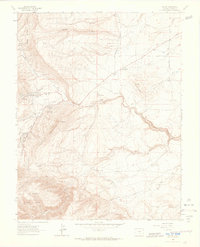
1963 Map of Beulah
USGS Topo · Published 1966About this map
Beulah serves as the focal point of this mid-century survey, situated at the edge of the San Isabel National Forest. The landscape is dominated by the dramatic uplift of Hogback Mountain and nearby peaks like Sugarloaf Mountain and Mt Signal. Waterways including North Creek and Middle Creek converge near the settlement, feeding into the North St Charles River as it carves through the eastern terrain.
Find a feature on this map
28 named features on this map. Tap any name to fly to it.
Don’t see what you’re looking for? This feature index may not catch every label — zoom into the map to look around manually.
Map Details
Editions of this 1963 Beulah Map
3 editions found
Other maps of this area

1889 · Canon City
USGS Topo · 1:125,000

1889 · Huerfano Park
USGS Topo · 1:125,000

1891 · Walsenburg
USGS Topo · 1:125,000

1891 · Pueblo
USGS Topo · 1:125,000

1892 · Huerfano Park
USGS Topo · 1:125,000

1892 · Canon City
USGS Topo · 1:125,000

1894 · Walsenburg
USGS Topo · 1:125,000

1894 · Pueblo
USGS Topo · 1:125,000

1896 · Pueblo
USGS Topo · 1:125,000

1897 · Pueblo
USGS Topo · 1:125,000