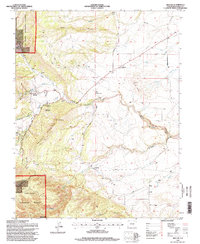
1994 Map of Beulah
USGS Topo · Published 1998About this map
The mountain-front community of Beulah serves as the focal point of this 1990s landscape, where the high plains meet the eastern edge of the Wet Mountains. Located just west of the San Isabel National Forest boundary, the settlement is surrounded by dramatic geological features like Hogback Mountain and the deep cuts of Wales Canyon. The residential character of Valley View and the agricultural presence of the Three R Ranch suggest a mix of mountain living and working land. Water distribution is clearly defined by the branching St Charles River and its numerous tributaries, including Middle Creek and Squirrel Creek. For those researching local history, the map provides precise locations for the Beulah Cem, the Filtration Plant, and smaller outposts such as Cedar Grove and Goodpasture, showing the transition from wild forest lands to settled ranching territory.
Find a feature on this map
31 named features on this map. Tap any name to fly to it.
Don’t see what you’re looking for? This feature index may not catch every label — zoom into the map to look around manually.
Map Details
Editions of this 1994 Beulah Map
2 editions found
Other maps of this area

1889 · Canon City
USGS Topo · 1:125,000

1889 · Huerfano Park
USGS Topo · 1:125,000

1891 · Walsenburg
USGS Topo · 1:125,000

1891 · Pueblo
USGS Topo · 1:125,000

1892 · Huerfano Park
USGS Topo · 1:125,000

1892 · Canon City
USGS Topo · 1:125,000

1894 · Walsenburg
USGS Topo · 1:125,000

1894 · Pueblo
USGS Topo · 1:125,000

1896 · Pueblo
USGS Topo · 1:125,000

1897 · Pueblo
USGS Topo · 1:125,000