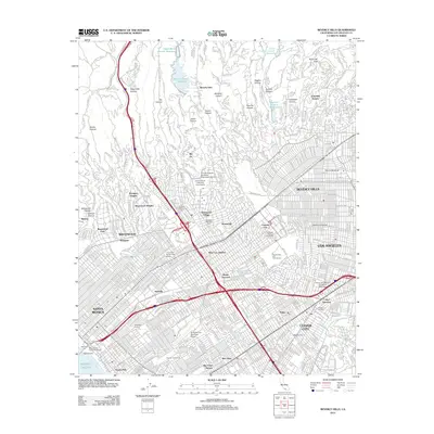
2012 Map of Beverly Hills
USGS Topo · Published 2012About this map
Beverly Hills and the surrounding Westside neighborhoods of Los Angeles are depicted here during a period of dense urban maturity. The map highlights the concentration of the global entertainment industry, featuring the sprawling grounds of Twentieth Century Fox Studios, MGM Studios, and Desilu Studios. This cultural landscape is further anchored by the University of California - Los Angeles campus and the adjacent Westwood Village, illustrating the area's role as a major academic and commercial hub.
Find a feature on this map
81 named features on this map. Tap any name to fly to it.
Don’t see what you’re looking for? This feature index may not catch every label — zoom into the map to look around manually.
Map Details
Editions of this 2012 Beverly Hills Map
This is the sole edition of this map. No revisions or reprints were ever made.
Other maps of this area

1894 · Los Angeles
USGS Topo · 1:62,500

1896 · Redondo
USGS Topo · 1:62,500

1896 · Santa Monica
USGS Topo · 1:62,500

1898 · Santa Monica
USGS Topo · 1:62,500

1900 · Los Angeles
USGS Topo · 1:62,500

1901 · Southern California Sheet No. 1
USGS Topo · 1:250,000
1902 · Santa Monica
USGS Topo · 1:62,500
1903 · Calabasas
USGS Topo · 1:62,500

1903 · Camulos
USGS Topo · 1:125,000

1904 · Southern California Sheet No. 1
USGS Topo · 1:250,000