
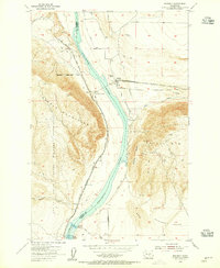
1954 Map of Beverly NE
USGS Topo · Published 1955About this map
Frenchman Hills dominate the northern terrain of this Grant County landscape, providing a natural barrier between the higher ridges and the descending Royal Slope to the south. The 1954 field check by the USGS captured a transitional moment for the region's agricultural infrastructure, most notably with the presence of the West Canal cutting across the northern reaches and a major roadway marked as Under Construction spanning the southern sections. These features illustrate the mid-century transformation of the arid Washington interior into a managed irrigation landscape. Local travel of the era relied on a network of Jeep Trails and standard Trails that navigated the dips of Low Gap and Low Gap Pass, while natural drainage was defined by the winding path of Sand Hollow.
Find a feature on this map
52 named features on this map. Tap any name to fly to it.
Don’t see what you’re looking for? This feature index may not catch every label — zoom into the map to look around manually.
Map Details
Editions of this 1954 Beverly NE Map
This is the sole edition of this map. No revisions or reprints were ever made.
Other maps of this area

1909 · Quincy
USGS Topo · 1:62,500

1910 · Quincy
USGS Topo · 1:62,500

1910 · Winchester
USGS Topo · 1:62,500

1911 · Red Rock
USGS Topo · 1:62,500

1912 · Beverly
USGS Topo · 1:62,500

1950 · Smyrna
USGS Topo · 1:62,500

1951 · Smyrna
USGS Topo · 1:62,500

1953 · Walla Walla
USGS Topo · 1:250,000

1953 · Ritzville
USGS Topo · 1:250,000
1954 · Beverly
USGS Topo · 1:24,000