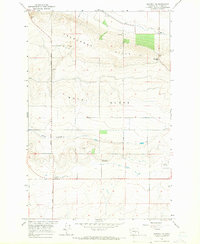
1965 Map of Beverly NE
USGS Topo · Published 1966About this map
Frenchman Hills dominate the northern landscape of this mid-1960s survey, illustrating a period of significant agricultural and utility development in Grant County. The map documents the engineering of the Columbia Basin Project, with an Aqueduct, Canal, and multiple Siphons cutting through the terrain to transform the Royal Slope. This irrigation infrastructure is anchored by the Sand Hollow Pumping Station and the Jericho Substation, showing the transition of this arid region into a managed agricultural corridor. Local transit is defined by a network of straight-line section roads including Beverly Burke Road and Adams Road. The presence of a U S Mil Res in the southeast and a scattered Mine and Borrow Pit indicate the diverse land use, from military reservation to resource extraction, during this era of Washington's interior growth.
Find a feature on this map
17 named features on this map. Tap any name to fly to it.
Don’t see what you’re looking for? This feature index may not catch every label — zoom into the map to look around manually.
Map Details
Editions of this 1965 Beverly NE Map
This is the sole edition of this map. No revisions or reprints were ever made.
Other maps of this area

1909 · Quincy
USGS Topo · 1:62,500

1910 · Quincy
USGS Topo · 1:62,500

1910 · Winchester
USGS Topo · 1:62,500

1911 · Red Rock
USGS Topo · 1:62,500

1912 · Beverly
USGS Topo · 1:62,500

1950 · Smyrna
USGS Topo · 1:62,500

1951 · Smyrna
USGS Topo · 1:62,500

1953 · Walla Walla
USGS Topo · 1:250,000

1953 · Ritzville
USGS Topo · 1:250,000

1954 · Beverly NE
USGS Topo · 1:24,000