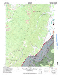
1995 Map of Beverly West
USGS Topo · Published 1998About this map
The Tygart River winds through the eastern portion of this West Virginia landscape, anchoring a series of valley settlements including Beverly, Dailey, and Valley Bend. This 1990s revision reflects a complex intersection of industry and rural community, where extensive strip mines and a Quarry in the north contrast with the protected lands of the Monongahela National Forest to the south. Local heritage is preserved in landmarks like the Homestead Sch and the Valley Bend Ch, while the terrain is defined by the massive spine of Rich Mountain separating the Roaring Creek Valley from the primary river basin. Transportation and utility networks are prominent, featuring the George Town Road and several major pipelines that traverse the ridges. The map also captures unique leisure and infrastructure details, such as a drive-in theater near the river and the Gaging Sta Burnt Bridge.
Find a feature on this map
54 named features on this map. Tap any name to fly to it.
Don’t see what you’re looking for? This feature index may not catch every label — zoom into the map to look around manually.
Map Details
Editions of this 1995 Beverly West Map
This is the sole edition of this map. No revisions or reprints were ever made.
Other maps of this area

1889 · Beverly
USGS Topo · 1:125,000

1892 · Beverly
USGS Topo · 1:125,000

1893 · Buckhannon
USGS Topo · 1:125,000

1896 · Buckhannon
USGS Topo · 1:125,000

1897 · Buckhannon
USGS Topo · 1:125,000

1909 · Elkins
USGS Topo · 1:62,500

1912 · Sago
USGS Topo · 1:48,000

1913 · Pickens
USGS Topo · 1:48,000

1914 · Sago
USGS Topo · 1:62,500

1915 · Pickens
USGS Topo · 1:62,500