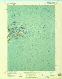
1956 Map of Biddeford Pool
USGS Topo · Published 1958About this map
The coastal village of Biddeford Pool anchors this 1956 survey, showing a landscape defined by its maritime heritage and the complex geography of Fletcher Neck. Situated at the edge of the Atlantic Ocean, the community is centered around the protective waters of The Pool and Wood Island Harbor. The map records significant local landmarks including the Marie Joseph Academy, the U. S. Coast Guard Station, and the expansive Abenakee Golf Club. Along the shore, Hills Beach and Fortunes Rocks Beach are punctuated by rocky features such as Fort Hill and East Point. The hydrography reveals a rugged seafloor with hazards like Ram Island Ledge and Negro Island Ledge, while a prominent Lighthouse on Wood Island and a Monument on Stage Islands mark the entrance to the harbor. This survey captures the mid-century character of this Maine resort and fishing community, illustrating the dense settlement patterns around Great Pond before further modern expansion.
Find a feature on this map
43 named features on this map. Tap any name to fly to it.
Don’t see what you’re looking for? This feature index may not catch every label — zoom into the map to look around manually.
Map Details
Editions of this 1956 Biddeford Pool Map
3 editions found
Other maps of this area

1891 · Portland
USGS Topo · 1:62,500

1891 · Biddeford
USGS Topo · 1:62,500

1893 · Biddeford
USGS Topo · 1:62,500

1893 · Portland
USGS Topo · 1:62,500

1893 · Casco Bay
USGS Topo · 1:62,500

1914 · Portland
USGS Topo · 1:48,000

1914 · Casco Bay
USGS Topo · 1:48,000

1916 · Portland
USGS Topo · 1:62,500

1916 · Casco Bay
USGS Topo · 1:62,500

1916 · Portland And Vicinity
USGS Topo · 1:62,500