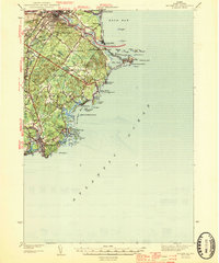
1944 Map of Biddeford
USGS Topo · Published 1944About this map
The Saco River serves as the primary artery of this mid-century coastal landscape, separating the sister cities of Saco and Biddeford. Along the jagged Atlantic coastline, the map documents a maritime economy defined by natural harbors and defensive infrastructure, featuring the Coast Guard Station at Fletcher Neck and the distinctive tidal inlet known as The Pool. Education and community life are grounded in numerous local landmarks, from St Francis College to the Stella Maris Sch and the Guinea Road Sch.
Find a feature on this map
69 named features on this map. Tap any name to fly to it.
Don’t see what you’re looking for? This feature index may not catch every label — zoom into the map to look around manually.
Map Details
Editions of this 1944 Biddeford Map
2 editions found
Other maps of this area

1891 · Portland
USGS Topo · 1:62,500

1891 · Biddeford
USGS Topo · 1:62,500

1891 · Kennebunk
USGS Topo · 1:62,500

1891 · Buxton
USGS Topo · 1:62,500

1892 · Buxton
USGS Topo · 1:62,500

1893 · Kennebunk
USGS Topo · 1:62,500

1893 · York
USGS Topo · 1:62,500

1893 · Biddeford
USGS Topo · 1:62,500

1893 · Portland
USGS Topo · 1:62,500

1893 · Casco Bay
USGS Topo · 1:62,500