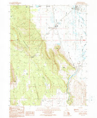
1990 Map of Bieber
USGS Topo · Published 1990About this map
Bieber and Nubieber anchor this high valley landscape at a time when the region's rail and water infrastructure remained central to local life. The Pit River winds through the eastern portion of the sheet, fed by a network of named sloughs like Bull Run Slough and Gobel Slough, which navigate the complex drainage of Big Valley. The western half of the map is dominated by the steep slopes of the Big Valley Mountains, where labels such as Big Valley Summit and Dixon Hill define the terrain. Local history is marked by features like the Intermountain Conservation Camp, the Bieber Station rail stop, and the small Cem located near the town center. Numerous water improvements, including the Thompson Reservoir and Hardin Res, illustrate the critical management of water for ranching and agriculture in this corner of Lassen County.
Find a feature on this map
32 named features on this map. Tap any name to fly to it.
Don’t see what you’re looking for? This feature index may not catch every label — zoom into the map to look around manually.
Map Details
Editions of this 1990 Bieber Map
This is the sole edition of this map. No revisions or reprints were ever made.
Other maps of this area

1886 · Lassen Peak
USGS Topo · 1:250,000

1886 · Modoc Lava Bed
USGS Topo · 1:250,000

1892 · Modoc Lava-Bed
USGS Topo · 1:250,000

1892 · Lassen Peak
USGS Topo · 1:250,000

1894 · Lassen Peak
USGS Topo · 1:250,000

1939 · Halls Flat
USGS Topo · 1:125,000

1954 · Alturas
USGS Topo · 1:250,000

1955 · Westwood
USGS Topo · 1:250,000

1957 · Little Valley
USGS Topo · 1:62,500

1957 · Jellico
USGS Topo · 1:62,500