
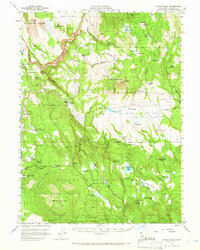
1957 Map of Little Valley
USGS Topo · Published 1959About this map
The Western Pacific RR carves a path through this high-altitude landscape where the Modoc and Lassen county lines meet, following the Pit River and navigating the steep corridors of Little Valley. In the late 1950s, the area was a center for both commercial logging and scientific forestry, evidenced by the Blacks Mountain Experimental Forest and several remote timber or ranching outposts.
Find a feature on this map
82 named features on this map. Tap any name to fly to it.
Don’t see what you’re looking for? This feature index may not catch every label — zoom into the map to look around manually.
Map Details
Editions of this 1957 Little Valley Map
2 editions found
Other maps of this area

1886 · Alturas
USGS Topo · 1:250,000

1886 · Honey Lake
USGS Topo · 1:250,000

1886 · Lassen Peak
USGS Topo · 1:250,000

1886 · Modoc Lava Bed
USGS Topo · 1:250,000

1891 · Honey Lake
USGS Topo · 1:250,000

1892 · Modoc Lava-Bed
USGS Topo · 1:250,000

1892 · Lassen Peak
USGS Topo · 1:250,000

1892 · Alturas
USGS Topo · 1:250,000

1893 · Honey Lake
USGS Topo · 1:250,000

1894 · Lassen Peak
USGS Topo · 1:250,000