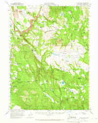
1957 Map of Little Valley
USGS Topo · Published 1966About this map
Little Valley sits at the heart of this high-desert and timber landscape within Lassen County, where the Western Pacific railroad tracks trace the contours of the Pit River and Horse Creek. The map documents a transition from cattle ranching to forestry, with the Blacks Mountain Experimental Forest and the State Game Refuge encompassing much of the terrain. Local history and genealogy interest is concentrated in specific labor and residential sites such as Puls Camp, Camp Harvey, and the Eldridge Homestead. Distinctive local landmarks including The Round Barn near the railroad line and high-altitude features like Bald Mountain and Harvey Mtn define the topography. Water resources were vital to the area's development, evidenced by the numerous reservoirs and springs, including Catfish Res, Straylor Lake, and the aptly named Russell Dairy Spring, indicating a history of livestock and dairy operations in this corner of the Modoc National Forest.
Find a feature on this map
85 named features on this map. Tap any name to fly to it.
Don’t see what you’re looking for? This feature index may not catch every label — zoom into the map to look around manually.
Map Details
Editions of this 1957 Little Valley Map
2 editions found

Other maps of this area

1886 · Alturas
USGS Topo · 1:250,000

1886 · Honey Lake
USGS Topo · 1:250,000

1886 · Lassen Peak
USGS Topo · 1:250,000

1886 · Modoc Lava Bed
USGS Topo · 1:250,000

1891 · Honey Lake
USGS Topo · 1:250,000

1892 · Modoc Lava-Bed
USGS Topo · 1:250,000

1892 · Lassen Peak
USGS Topo · 1:250,000

1892 · Alturas
USGS Topo · 1:250,000

1893 · Honey Lake
USGS Topo · 1:250,000

1894 · Lassen Peak
USGS Topo · 1:250,000