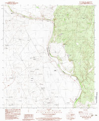
1983 Map of Big Apache Hill
USGS Topo · Published 1983About this map
The Rio Grande Rio Bravo carves a winding path through this borderland region, marking the international boundary between Texas and Coahuila. This 1983 survey captures a landscape defined by ranching and small outposts, with numerous named points such as Sarita (San Ramon), San Eduardo, and Los Apaches scattered across the arid terrain. The map provides a detailed view of the local topography, dominated by the distinct summits of Big Apache Hill and Little Apache Hill. To the east of the river, water management is evident through features like Gatito Tank and Rock Tank, while the western side is marked by a network of trails and roads including the TG (Fuera De Uso). This documentation reflects the cross-border connectivity of the era, linking settlements like Santa Eulalia and El Milagro across the river valley.
Find a feature on this map
40 named features on this map. Tap any name to fly to it.
Don’t see what you’re looking for? This feature index may not catch every label — zoom into the map to look around manually.
Map Details
Editions of this 1983 Big Apache Hill Map
This is the sole edition of this map. No revisions or reprints were ever made.
Other maps of this area

1923 · Palafox
USGS Topo · 1:62,500

1929 · Cotulla
USGS Topo · 1:125,000

1940 · San Loranzo Creek
USGS Topo · 1:62,500

1940 · Chupadera
USGS Topo · 1:62,500

1953 · Crystal City
USGS Topo · 1:250,000

1955 · Crystal City
USGS Topo · 1:250,000

1956 · Laredo
USGS Topo · 1:250,000

1958 · Eagle Pass
USGS Topo · 1:250,000

1961 · Crystal City
USGS Topo · 1:250,000

1965 · Eagle Pass
USGS Topo · 1:250,000