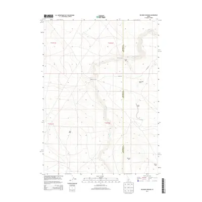
2013 Map of Big Bend Crossing
USGS Topo · Published 2013About this map
Devil Cr carves a deep path through this high desert plateau along the border of Owyhee and Twin Falls counties. This landscape is defined by its dramatic topographic relief, where the watercourse drops through narrow channels and widening basins like Cedar Draw and John Boyd Draw. Historically significant transit points are noted along the creek, including Old Bend Crossing and the downstream Big Bend Crossing, which served as critical passage points across the waterway. The area's volcanic geological history is evident in the prominent volcanic landforms of Black Butte in the west and Marshall Butte to the south, both of which serve as major navigational landmarks. Modern infrastructure is limited to the winding path of Big Bend Rd, which provides access to these remote draws and canyons.
Find a feature on this map
14 named features on this map. Tap any name to fly to it.
Don’t see what you’re looking for? This feature index may not catch every label — zoom into the map to look around manually.
Map Details
Editions of this 2013 Big Bend Crossing Map
This is the sole edition of this map. No revisions or reprints were ever made.
Other maps of this area

1955 · Twin Falls
USGS Topo · 1:250,000

1958 · Twin Falls
USGS Topo · 1:250,000

1964 · Roseworth
USGS Topo · 1:24,000

1965 · Tuanna Butte
USGS Topo · 1:24,000

1977 · Cedar Creek Reservoir
USGS Topo · 1:24,000

1979 · Salls Crossing
USGS Topo · 1:24,000

1979 · Coonskin Butte NE
USGS Topo · 1:24,000
1979 · Roseworth
USGS Topo · 1:24,000

1979 · Coonskin Butte
USGS Topo · 1:24,000
1979 · Tuanna Butte
USGS Topo · 1:24,000