
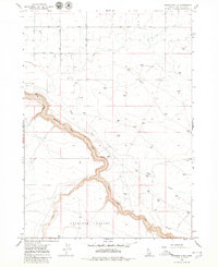
1965 Map of Tuanna Butte
USGS Topo · Published 1966About this map
Salmon Falls Creek carves a deep, winding canyon through this high desert plateau, dictating the movement of travelers and water in Twin Falls County. The topography is dominated by two prominent volcanic landmarks, Tuanna Butte and Devil Creek Butte, which rise above the surrounding sagebrush plains. A network of early infrastructure is evident through named thoroughfares like North Road and East Rd., while more primitive routes are marked by a Jeep Trail cutting across the landscape. The confluence of these waterways and the rugged descent into the canyon at Big Bend Crossing highlights a classic Idaho high-desert environment before modern land-use patterns fully reshaped the area. This 1960s survey provides a clear view of the drainage patterns of Devil Creek and Blue Gulch Creek as they feed into the primary gorge.
Find a feature on this map
10 named features on this map. Tap any name to fly to it.
Don’t see what you’re looking for? This feature index may not catch every label — zoom into the map to look around manually.
Map Details
Editions of this 1965 Tuanna Butte Map
This is the sole edition of this map. No revisions or reprints were ever made.
Other maps of this area

1955 · Twin Falls
USGS Topo · 1:250,000

1958 · Twin Falls
USGS Topo · 1:250,000

1958 · Buhl
USGS Topo · 1:24,000

1959 · Buhl
USGS Topo · 1:62,500

1959 · Crows Nest
USGS Topo · 1:62,500

1964 · Roseworth
USGS Topo · 1:24,000

1965 · Roseworth SE
USGS Topo · 1:24,000

1965 · Roseworth NE
USGS Topo · 1:24,000

1979 · Coonskin Butte NE
USGS Topo · 1:24,000
1979 · Roseworth NE
USGS Topo · 1:24,000