
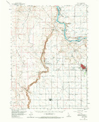
1959 Map of Buhl
USGS Topo · Published 1961About this map
Buhl anchors the eastern edge of this mid-century survey, a period when the agricultural economy of the Magic Valley relied heavily on an intricate network of irrigation including the Low Line Canal. The landscape is defined by the dramatic incision of the Snake River and Salmon Falls Creek, where geological landmarks like Balanced Rock and the cataracts at Thousand Springs draw the eye. Cultural sites of the era are well-documented, from the National Guard Armory and a Drive-in Theater in town to the Banbury Natatorium near the river. This map captures the region's unique intersection of recreation and industry, evidenced by the proximity of Clear Lakes and the Fish Hatchery to the Military Reservation (Rifle Range). Small rural centers like Castleford and Fairview are shown alongside local landmarks such as the Lucerne Sch, providing a detailed look at the settlement pattern before modern development.
Find a feature on this map
44 named features on this map. Tap any name to fly to it.
Don’t see what you’re looking for? This feature index may not catch every label — zoom into the map to look around manually.
Map Details
Editions of this 1959 Buhl Map
2 editions found
Other maps of this area

1949 · Pasadena Valley
USGS Topo · 1:62,500

1949 · Thousand Springs
USGS Topo · 1:24,000

1949 · Tuttle
USGS Topo · 1:24,000

1949 · Hagerman
USGS Topo · 1:24,000

1949 · Indian Butte
USGS Topo · 1:24,000

1950 · Hagerman
USGS Topo · 1:24,000
1950 · Indian Butte
USGS Topo · 1:24,000

1950 · Niagara Springs
USGS Topo · 1:24,000

1950 · Jerome
USGS Topo · 1:62,500

1951 · Thousand Springs
USGS Topo · 1:24,000