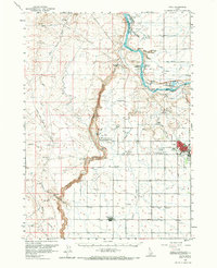
1959 Map of Buhl
USGS Topo · Published 1966About this map
Snake River basalt canyons and complex hydrography dominate this mid-century look at Idaho's Magic Valley. The landscape transitions from the dramatic river gorge at Thousand Springs and Kanaka Rapids to the irrigated agricultural lands surrounding Buhl and Castleford. Water management is central to the area's development, evidenced by the Low Line Canal and numerous gaging stations. Cultural landmarks of the era include the Banbury Natatorium, a Drive-in Theater east of Buhl, and the Lucerne Sch. Geologic curiosities are plentiful, from the Balanced Rock in the south to the Devils Washboard Falls along the river. The presence of a Military Reservation and the Buhl Municipal Airport reflects the diverse land use in Twin Falls County during this period of post-war growth.
Find a feature on this map
41 named features on this map. Tap any name to fly to it.
Don’t see what you’re looking for? This feature index may not catch every label — zoom into the map to look around manually.
Map Details
Editions of this 1959 Buhl Map
2 editions found

Other maps of this area

1949 · Pasadena Valley
USGS Topo · 1:62,500

1949 · Thousand Springs
USGS Topo · 1:24,000

1949 · Tuttle
USGS Topo · 1:24,000

1949 · Hagerman
USGS Topo · 1:24,000

1949 · Indian Butte
USGS Topo · 1:24,000

1950 · Hagerman
USGS Topo · 1:24,000
1950 · Indian Butte
USGS Topo · 1:24,000

1950 · Niagara Springs
USGS Topo · 1:24,000

1950 · Jerome
USGS Topo · 1:62,500

1951 · Thousand Springs
USGS Topo · 1:24,000