
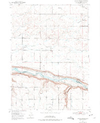
1950 Map of Niagara Springs
USGS Topo · Published 1952About this map
Snake River canyon walls define this 1950s landscape, marking the boundary between Gooding and Twin Falls counties. The map illustrates a complex hydraulic environment where natural features like Niagara Springs and Crystal Springs meet an extensive network of human-made infrastructure, including the Irrigation Ditch systems and a Seepage Tunnel. The agricultural development of the Snake River Plain is evident in the presence of the Orchard Valley School and the already noted Cedar Draw School (Aban'd), reflecting shifts in local rural populations. Transport and industry are anchored by the Union Pacific railroad at Appleton in the north and the Bob Barton Highway crossing the central plains. Unique landmarks like the private Fish Hatchery and an Airstrip (Pvt) provide specific points of interest for local history researchers and genealogists tracing family lands near the Crystal Springs Grade.
Find a feature on this map
21 named features on this map. Tap any name to fly to it.
Don’t see what you’re looking for? This feature index may not catch every label — zoom into the map to look around manually.
Map Details
Editions of this 1950 Niagara Springs Map
2 editions found
Other maps of this area

1949 · Thousand Springs
USGS Topo · 1:24,000

1949 · Tuttle
USGS Topo · 1:24,000

1950 · Filer
USGS Topo · 1:24,000

1950 · Jerome
USGS Topo · 1:24,000

1950 · Jerome
USGS Topo · 1:62,500

1951 · Thousand Springs
USGS Topo · 1:24,000

1951 · Tuttle
USGS Topo · 1:24,000

1951 · Clover
USGS Topo · 1:24,000

1954 · Thousand Springs
USGS Topo · 1:24,000

1955 · Twin Falls
USGS Topo · 1:250,000