
1950 Map of Jerome
USGS Topo · Published 1959About this map
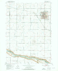
Jerome serves as the central hub of this agricultural landscape in 1950, organized around a dense network of irrigation infrastructure such as the Union Pacific Ditch and numerous smaller Irrigation Ditches. The town is well-established with civic landmarks including the Court House, City Hall, and the County Fairgrounds. To the south, the terrain drops dramatically toward the Snake River, where Ellisons Springs and the turbulent Auger Falls mark the canyon edge. This survey documents a community defined by its water management and educational network, featuring local landmarks like Appleton School and Canyonside School. The presence of the Union Pacific railroad and Jerome Sta highlights the importance of rail transport for the region's produce. Notable terrain features like Sonnickson Butte provide a vertical contrast to the surrounding fields, while smaller outlying points like Haytown and Hydra show the early sprawl of rural settlement.
Find a feature on this map
34 named features on this map. Tap any name to fly to it.
Don’t see what you’re looking for? This feature index may not catch every label — zoom into the map to look around manually.
Map Details
Editions of this 1950 Jerome Map
2 editions found
Other maps of this area

1950 · Niagara Springs
USGS Topo · 1:24,000

1950 · Filer
USGS Topo · 1:24,000

1950 · Jerome
USGS Topo · 1:62,500

1951 · Clover
USGS Topo · 1:24,000

1955 · Twin Falls
USGS Topo · 1:250,000

1958 · Twin Falls
USGS Topo · 1:250,000

1964 · Falls City
USGS Topo · 1:24,000

1964 · Twin Falls
USGS Topo · 1:24,000
1971 · Wendell
USGS Topo · 1:24,000
1971 · Gooding SE
USGS Topo · 1:24,000