
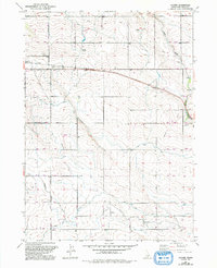
1951 Map of Clover
USGS Topo · Published 1951About this map
The Union Pacific railroad cuts through the heart of this agricultural landscape in the early 1950s, connecting the settlement of Buhl to eastern markets. This area of Twin Falls County reveals a highly managed water system essential for High Desert farming, dominated by the High Line Canal and Low Line Canal which navigate the contours of the terrain. The map is particularly rich for local genealogy, capturing a dense network of rural school districts including Washington Sch, Syringa Sch, and Poplar Hill School. The presence of the Cedar Draw Sch (Aban'd) and Superior Sch (Aban'd) suggests shifting populations and the consolidation of rural education during this era. Land drainage and irrigation are further detailed through several Seepage Tunnels and the winding course of Cedar Draw.
Find a feature on this map
20 named features on this map. Tap any name to fly to it.
Don’t see what you’re looking for? This feature index may not catch every label — zoom into the map to look around manually.
Map Details
Editions of this 1951 Clover Map
2 editions found
Other maps of this area

1949 · Thousand Springs
USGS Topo · 1:24,000

1950 · Niagara Springs
USGS Topo · 1:24,000

1950 · Filer
USGS Topo · 1:24,000

1950 · Jerome
USGS Topo · 1:24,000

1950 · Jerome
USGS Topo · 1:62,500

1951 · Thousand Springs
USGS Topo · 1:24,000

1954 · Thousand Springs
USGS Topo · 1:24,000

1955 · Twin Falls
USGS Topo · 1:250,000

1958 · Twin Falls
USGS Topo · 1:250,000

1958 · Buhl
USGS Topo · 1:24,000