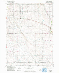
1951 Map of Clover
USGS Topo · Published 1992About this map
Clover serves as a central point of reference in this landscape of southern Idaho, where an intricate network of water management defines the region's agricultural character. This survey illustrates the transition from natural drainage to engineered irrigation, with the Low Line Canal and High Line Canal cutting across the terrain alongside an extensive Irrigation Ditch system. These features, coupled with numerous Seepage Tunnels and a Filter Pond, speak to the intensive water engineering required to support the local economy during the mid-20th century.
Find a feature on this map
19 named features on this map. Tap any name to fly to it.
Don’t see what you’re looking for? This feature index may not catch every label — zoom into the map to look around manually.
Map Details
Editions of this 1951 Clover Map
2 editions found
Other maps of this area

1949 · Thousand Springs
USGS Topo · 1:24,000

1950 · Niagara Springs
USGS Topo · 1:24,000

1950 · Filer
USGS Topo · 1:24,000

1950 · Jerome
USGS Topo · 1:24,000

1950 · Jerome
USGS Topo · 1:62,500

1951 · Thousand Springs
USGS Topo · 1:24,000

1951 · Clover
USGS Topo · 1:24,000

1954 · Thousand Springs
USGS Topo · 1:24,000

1955 · Twin Falls
USGS Topo · 1:250,000

1958 · Twin Falls
USGS Topo · 1:250,000