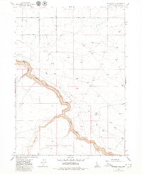
1979 Map of Roseworth NE
USGS Topo · Published 1980About this map
Salmon Falls Creek winds through the high desert of Twin Falls County, carving a deep canyon that dominates this landscape. The 1979 survey captures the rugged hydrology of the region, where Deep Creek and Cedar Creek feed into the primary gorge. A distinct human imprint is visible at Lilly Grade, a road that descends sharply into the canyon near Mile 26. Unlike the structured grid of the agricultural plains to the north, the terrain near Antelope Pocket remains largely open, defined by elevation changes and remote water infrastructure. Researchers will find numerous water tanks scattered across the high ground, illustrating the essential cattle-grazing economy of this Idaho ranching country. The placement of these markers alongside specific river milestones like Mile 30 and Mile 34 provides a precise spatial record of how the canyon was navigated and utilized in the late twentieth century.
Find a feature on this map
10 named features on this map. Tap any name to fly to it.
Don’t see what you’re looking for? This feature index may not catch every label — zoom into the map to look around manually.
Map Details
Editions of this 1979 Roseworth NE Map
This is the sole edition of this map. No revisions or reprints were ever made.
Other maps of this area

1950 · Jerome
USGS Topo · 1:62,500

1951 · Clover
USGS Topo · 1:24,000

1955 · Twin Falls
USGS Topo · 1:250,000

1958 · Twin Falls
USGS Topo · 1:250,000

1958 · Buhl
USGS Topo · 1:24,000

1959 · Buhl
USGS Topo · 1:62,500

1964 · Roseworth
USGS Topo · 1:24,000

1965 · Hollister SW
USGS Topo · 1:24,000

1965 · Roseworth SE
USGS Topo · 1:24,000

1965 · Roseworth NE
USGS Topo · 1:24,000