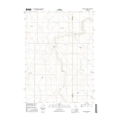
2017 Map of Big Bend Crossing
USGS Topo · Published 2017About this map
The high desert landscape of the Idaho borderlands is defined by deep drainages and volcanic rises, most notably at Big Bend Crossing where Big Bend Rd navigates the winding course of Devil Cr. This 2017 survey reveals the intricate topography of southwestern Twin Falls County, where the terrain is punctuated by significant landmarks like Black Butte, Marshall Butte, and the northern slope of Coonskin Butte. The map illustrates a series of distinct erosional features, including Cedar Draw, Worley Draw, and John Boyd Draw, which carve into the high plateau near the boundary with Owyhee County. This area represents a transition point in the high country where local roads follow the natural contours of the draws, providing a clear picture of the modern-day trail and waterway network in this corner of the state.
Find a feature on this map
14 named features on this map. Tap any name to fly to it.
Don’t see what you’re looking for? This feature index may not catch every label — zoom into the map to look around manually.
Map Details
Editions of this 2017 Big Bend Crossing Map
This is the sole edition of this map. No revisions or reprints were ever made.
Other maps of this area

1955 · Twin Falls
USGS Topo · 1:250,000

1958 · Twin Falls
USGS Topo · 1:250,000

1964 · Roseworth
USGS Topo · 1:24,000

1965 · Tuanna Butte
USGS Topo · 1:24,000

1977 · Cedar Creek Reservoir
USGS Topo · 1:24,000

1979 · Salls Crossing
USGS Topo · 1:24,000

1979 · Coonskin Butte NE
USGS Topo · 1:24,000
1979 · Roseworth
USGS Topo · 1:24,000

1979 · Coonskin Butte
USGS Topo · 1:24,000
1979 · Tuanna Butte
USGS Topo · 1:24,000