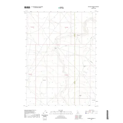
2020 Map of Big Bend Crossing
USGS Topo · Published 2020About this map
Devil Cr carves a winding path through the high desert landscape of this southern Idaho region, defining the local topography and historical crossing points. The small settlement of Big Bend Crossing serves as a primary reference point along the Big Bend Rd, where the route meets the creek in a deep drainage. The map reveals a land structured by volcanic landforms and erosional features, dominated by prominent elevations such as Black Butte, Marshall Butte, and Coonskin Butte. This area marks the political boundary between Owyhee and Twin Falls counties, a line that cuts through the high plateaus and several natural drainages including Cedar Draw, John-Boyd Draw, and Worley Draw. The layout of these draws and the placement of the named buttes reflect a classic Great Basin environment where water sources and high-ground landmarks were critical for navigation and early land use.
Find a feature on this map
14 named features on this map. Tap any name to fly to it.
Don’t see what you’re looking for? This feature index may not catch every label — zoom into the map to look around manually.
Map Details
Editions of this 2020 Big Bend Crossing Map
This is the sole edition of this map. No revisions or reprints were ever made.
Other maps of this area

1955 · Twin Falls
USGS Topo · 1:250,000

1958 · Twin Falls
USGS Topo · 1:250,000

1964 · Roseworth
USGS Topo · 1:24,000

1965 · Tuanna Butte
USGS Topo · 1:24,000

1977 · Cedar Creek Reservoir
USGS Topo · 1:24,000

1979 · Salls Crossing
USGS Topo · 1:24,000

1979 · Coonskin Butte NE
USGS Topo · 1:24,000
1979 · Roseworth
USGS Topo · 1:24,000

1979 · Coonskin Butte
USGS Topo · 1:24,000
1979 · Tuanna Butte
USGS Topo · 1:24,000