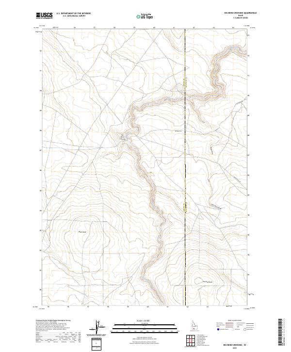
2023 Map of Big Bend Crossing
USGS Topo · Published 2023About this map
Big Bend Crossing serves as a central reference point in this high desert landscape along the border of Owyhee and Twin Falls counties. The terrain is defined by the winding course of Devil Creek, which carves a deep canyon through the volcanic plateau. This 2023 survey illustrates how water and topography dictate human movement, with Big Bend Rd navigating the rim and various draws like Cedar Draw and John Boyd Draw providing natural drainage into the creek bed below.
Find a feature on this map
13 named features on this map. Tap any name to fly to it.
Don’t see what you’re looking for? This feature index may not catch every label — zoom into the map to look around manually.
Map Details
Editions of this 2023 Big Bend Crossing Map
This is the sole edition of this map. No revisions or reprints were ever made.
Other maps of this area

1955 · Twin Falls
USGS Topo · 1:250,000

1958 · Twin Falls
USGS Topo · 1:250,000

1964 · Roseworth
USGS Topo · 1:24,000

1965 · Tuanna Butte
USGS Topo · 1:24,000

1977 · Cedar Creek Reservoir
USGS Topo · 1:24,000

1979 · Salls Crossing
USGS Topo · 1:24,000

1979 · Coonskin Butte NE
USGS Topo · 1:24,000
1979 · Roseworth
USGS Topo · 1:24,000

1979 · Coonskin Butte
USGS Topo · 1:24,000
1979 · Tuanna Butte
USGS Topo · 1:24,000