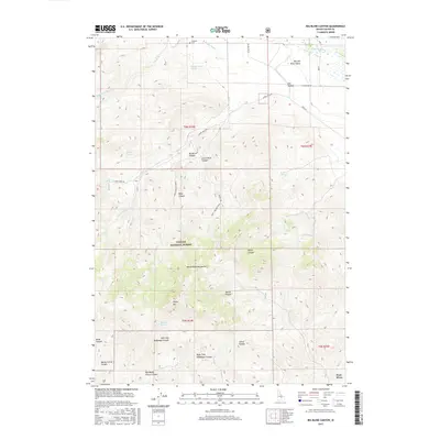
2017 Map of Big Blind Canyon
USGS Topo · Published 2017About this map
Challis National Forest dominates the high-elevation terrain of this Custer County landscape, where the White Knob Mountains rise sharply above the Big Lost River Valley. The mapping of this area reveals a complex network of canyons and gulches, including Big Blind Canyon, Marsh Canyon, and the curiously named Box Bailey Corral Canyon. Water management is central to the lower elevations, where the Big Lost River is diverted into the Rodger Ditch and Darlington Ditch to support local agricultural needs.
Find a feature on this map
39 named features on this map. Tap any name to fly to it.
Don’t see what you’re looking for? This feature index may not catch every label — zoom into the map to look around manually.
Map Details
Editions of this 2017 Big Blind Canyon Map
This is the sole edition of this map. No revisions or reprints were ever made.
Other maps of this area

1935 · MacKay
USGS Topo · 1:96,000

1940 · Mackay
USGS Topo · 1:62,500

1955 · Idaho Falls
USGS Topo · 1:250,000

1958 · Idaho Falls
USGS Topo · 1:250,000

1960 · Grouse
USGS Topo · 1:62,500

1960 · Mackay
USGS Topo · 1:62,500

1969 · Darlington
USGS Topo · 1:24,000
1969 · Methodist Creek
USGS Topo · 1:24,000

1972 · Appendicitis Hill
USGS Topo · 1:24,000
1988 · Arco
USGS Topo · 1:100,000