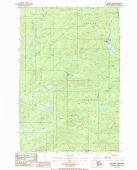
1986 Map of Big Brook Lake
USGS Topo · Published 1986About this map
Big Brook Lake sits at the heart of this North Woods territory, where the complex hydrology of northern Aroostook County is revealed through a network of winding waterways. The landscape is dominated by the convergence of Big Brook and McKeen Brook, flowing through townships like T 14 R 10 W E L S and T 13 R 11 W E L S. A distinctive feature known as The Corduroys suggests the presence of specialized local terrain or traditional road-building methods used in this timber-rich region.
Find a feature on this map
17 named features on this map. Tap any name to fly to it.
Don’t see what you’re looking for? This feature index may not catch every label — zoom into the map to look around manually.
Map Details
Editions of this 1986 Big Brook Lake Map
This is the sole edition of this map. No revisions or reprints were ever made.
Other maps of this area

1931 · Fish River Lake
USGS Topo · 1:48,000

1931 · Mooseleuk Lake
USGS Topo · 1:48,000

1932 · Musquacook Lakes
USGS Topo · 1:48,000

1932 · Allagash Falls
USGS Topo · 1:48,000

1935 · Musquacook Lakes
USGS Topo · 1:62,500

1935 · Fish River Lake
USGS Topo · 1:62,500

1935 · Mooseleuk Lake
USGS Topo · 1:62,500

1935 · Allagash Falls
USGS Topo · 1:62,500

1954 · Presque Isle
USGS Topo · 1:250,000

1956 · Allagash Falls
USGS Topo · 1:50,000