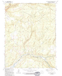
1994 Map of Big Bucktail Creek
USGS Topo · Published 1994About this map
The San Miguel River cuts a deep course through the southern portion of this landscape, flanked by the San Miguel Canyon Highway. This 1990s-era documentation reveals a terrain heavily influenced by water management and mineral extraction, featuring several mines and a Gravel Pit near the riverbanks. High above the canyon floor, Pinto Mesa and Tabeguache Basin define the upland geography within the Uncompahgre National Forest.
Find a feature on this map
29 named features on this map. Tap any name to fly to it.
Don’t see what you’re looking for? This feature index may not catch every label — zoom into the map to look around manually.
Map Details
Editions of this 1994 Big Bucktail Creek Map
This is the sole edition of this map. No revisions or reprints were ever made.
Other maps of this area

1916 · Paradox Valley
USGS Topo · 1:125,000

1922 · Paradox Valley
USGS Topo · 1:125,000

1956 · Moab
USGS Topo · 1:250,000

1959 · Moab
USGS Topo · 1:250,000

1960 · Moab
USGS Topo · 1:250,000
1960 · Nucla
USGS Topo · 1:24,000
1960 · Nucla
USGS Topo · 1:62,500
1960 · Windy Point
USGS Topo · 1:24,000

1962 · Moab
USGS Topo · 1:250,000

1964 · Moab
USGS Topo · 1:250,000