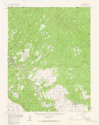
1960 Map of Nucla
USGS Topo · Published 1961About this map
Mining operations and remote ranching outposts define this 1960 landscape along the San Miguel River in western Colorado. The settlement of Uravan serves as a focal point for the region's industrial activity, surrounded by a dense network of claims including the Sunbeam Mine, Long Park No 6 Mine, and Wright Mines. This era represents a peak of activity in the Colorado Plateau's mineral belts, evidenced by the numerous specialized mines and the airstrip serving the isolated community.
Find a feature on this map
105 named features on this map. Tap any name to fly to it.
Don’t see what you’re looking for? This feature index may not catch every label — zoom into the map to look around manually.
Map Details
Editions of this 1960 Nucla Map
2 editions found
Other maps of this area

1916 · Paradox Valley
USGS Topo · 1:125,000

1922 · Paradox Valley
USGS Topo · 1:125,000

1948 · Bull Canyon
USGS Topo · 1:24,000

1948 · Uravan
USGS Topo · 1:24,000

1948 · Naturita NW
USGS Topo · 1:24,000

1949 · Bull Canyon
USGS Topo · 1:24,000

1949 · Davis Mesa
USGS Topo · 1:24,000

1949 · Uravan
USGS Topo · 1:24,000

1949 · Naturita NW
USGS Topo · 1:24,000

1949 · Atkinson Creek
USGS Topo · 1:24,000