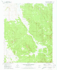
1981 Map of Big Bud Tank
USGS Topo · Published 1981About this map
Big Bud Tank and a series of numbered water catchments anchor this high-altitude landscape in the Coconino plateau during the early 1980s. The presence of Tank No 1 (Water), Tank No 2 (Water), and Tank No 3 (Water) reflects a meticulously managed watershed where water collection was critical for land use, likely supporting livestock grazing across the vast townships of T 25 N and T 26 N. Drainage flows through the area via Rodgers Draw, while named features like Murphy-Johnson Tank suggest specific ranching or local family associations. This area of Coconino County is defined by its subtle topographic shifts and the essential network of tanks and a Water Tank that sustained activity in this part of northern Arizona before the expansion of more modern infrastructure.
Find a feature on this map
11 named features on this map. Tap any name to fly to it.
Don’t see what you’re looking for? This feature index may not catch every label — zoom into the map to look around manually.
Map Details
Editions of this 1981 Big Bud Tank Map
This is the sole edition of this map. No revisions or reprints were ever made.
Other maps of this area

1886 · Chino
USGS Topo · 1:250,000

1891 · Chino
USGS Topo · 1:250,000

1948 · Williams
USGS Topo · 1:250,000

1954 · Williams
USGS Topo · 1:250,000

1956 · Williams
USGS Topo · 1:250,000

1960 · Williams
USGS Topo · 1:250,000

1961 · Williams
USGS Topo · 1:250,000
1973 · Mount Floyd
USGS Topo · 1:24,000
1980 · Rose Well Camp West
USGS Topo · 1:24,000
1980 · Black Tank
USGS Topo · 1:24,000