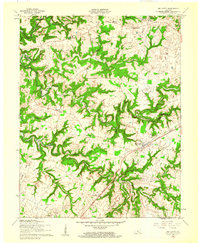
1960 Map of Big Clifty
USGS Topo · Published 1961About this map
Big Clifty and the surrounding borderlands of Hardin and Grayson counties are defined by the winding course of Meeting Creek and the rising waters of the Rough River Reservoir. The Illinois Central Railroad serves as a central corridor for the region, linking settlements like Saint Paul and West Clifty. This 1960 revision captures the local social fabric through its network of rural institutions, including St Pauls Ch, St Elizabeth Ch, and Pleasant Grove Ch. The landscape is etched with distinctive family-named terrain, such as Portman Hollow and Decker Ridge, alongside smaller outposts like Limp and Tar Hill. The placement of the Johnson School and various Cem sites provides essential data for those tracing the development of these tight-knit Kentucky communities before further modern infrastructure changes.
Find a feature on this map
26 named features on this map. Tap any name to fly to it.
Don’t see what you’re looking for? This feature index may not catch every label — zoom into the map to look around manually.
Map Details
Editions of this 1960 Big Clifty Map
This is the sole edition of this map. No revisions or reprints were ever made.
Other maps of this area

1922 · Leitchfield
USGS Topo · 1:48,000

1925 · Cub Run
USGS Topo · 1:62,500

1925 · Leitchfield
USGS Topo · 1:62,500

1932 · Big Clifty
USGS Topo · 1:62,500

1949 · Constantine
USGS Topo · 1:24,000

1949 · Summit
USGS Topo · 1:24,000
1949 · Howe Valley
USGS Topo · 1:24,000

1949 · Big Clifty
USGS Topo · 1:24,000

1949 · Big Clifty
USGS Topo · 1:62,500

1953 · Custer
USGS Topo · 1:24,000