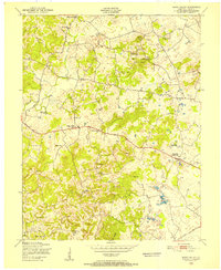
1949 Map of Howe Valley
USGS Topo · Published 1952About this map
The Howe Valley landscape in Kentucky’s Hardin County is defined by a dense network of small rural settlements and agricultural landmarks recorded during the late 1940s. The area is dotted with family-named features and local hubs like Miller Corners and Franklin Crossroads, while the Illinois Central railroad cuts through the southeast corner, connecting this rural interior to larger markets. Small country churches and schoolhouses serve as the primary social anchors for these communities, including Yates Chapel, Ridge Spring Ch, and the Richardson Sch.
Find a feature on this map
36 named features on this map. Tap any name to fly to it.
Don’t see what you’re looking for? This feature index may not catch every label — zoom into the map to look around manually.
Map Details
Editions of this 1949 Howe Valley Map
This is the sole edition of this map. No revisions or reprints were ever made.
Other maps of this area

1932 · Big Clifty
USGS Topo · 1:62,500

1935 · Elizabethtown
USGS Topo · 1:48,000

1936 · Vine Grove
USGS Topo · 1:62,500

1938 · Elizabethtown
USGS Topo · 1:62,500

1941 · Ekron
USGS Topo · 1:62,500

1943 · Vine Grove
USGS Topo · 1:62,500

1946 · Vine Grove
USGS Topo · 1:24,000

1946 · Vine Grove
USGS Topo · 1:62,500

1947 · Ekron
USGS Topo · 1:62,500
1948 · Flaherty
USGS Topo · 1:24,000