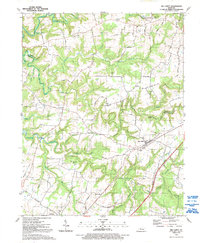
1991 Map of Big Clifty
USGS Topo · Published 1992About this map
Big Clifty and the rural hills of northern Grayson Co are defined by the deep incisions of Meeting Creek and the Clifty Creek system. This early 1990s survey, updated from late 1980s aerial photography, shows a landscape of ridge-top farms and hollow-bottom roads. The Western Kentucky Rwy cuts a sharp line across the southeastern quadrant, serving the corridor between Big Clifty and West Clifty. Local heritage is anchored by several rural landmarks, including the Pleasant Grove Ch and Smith Chapel, while educational life is represented by the Western Consolidated Sch and Goodman Sch. To the northwest, the map captures the southern reaches of Rough River Lake and its confluence with Rough River, highlighting the transition from the rolling agricultural uplands to the inundated valleys of the regional watershed.
Find a feature on this map
55 named features on this map. Tap any name to fly to it.
Don’t see what you’re looking for? This feature index may not catch every label — zoom into the map to look around manually.
Map Details
Editions of this 1991 Big Clifty Map
This is the sole edition of this map. No revisions or reprints were ever made.
Other maps of this area

1922 · Leitchfield
USGS Topo · 1:48,000

1925 · Cub Run
USGS Topo · 1:62,500

1925 · Leitchfield
USGS Topo · 1:62,500

1932 · Big Clifty
USGS Topo · 1:62,500

1949 · Constantine
USGS Topo · 1:24,000

1949 · Summit
USGS Topo · 1:24,000
1949 · Howe Valley
USGS Topo · 1:24,000

1949 · Big Clifty
USGS Topo · 1:24,000

1949 · Big Clifty
USGS Topo · 1:62,500

1953 · Custer
USGS Topo · 1:24,000