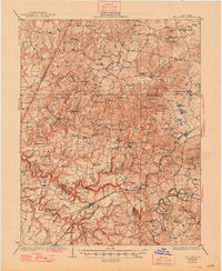
1932 Map of Big Clifty
USGS Topo · Published 1948About this map
Big Clifty serves as a focal point for this landscape where the Kentucky asphalt industry was taking shape between the World Wars. Local extractors such as the Rock Crush Asphalt Mine and Valley Asphalt Mine highlight the geological wealth of the area, while the discovery of Wonderland Caverns near the Nolin River suggests early interest in the region's subterranean features. The rugged terrain, punctuated by Buzzard Cliff and Laurel Ridge, is heavily dotted with rural community life, featuring an extensive network of schools and churches including the Howe Valley High School and Meeting Creek Church. Along the Rough River and its tributaries, small commerce centers like Calverts Store and Stephensburg provide a look at the social fabric of Grayson and Hardin counties before modern development reshaped these valley communities.
Find a feature on this map
86 named features on this map. Tap any name to fly to it.
Don’t see what you’re looking for? This feature index may not catch every label — zoom into the map to look around manually.
Map Details
Editions of this 1932 Big Clifty Map
5 editions found
Other maps of this area

1922 · Leitchfield
USGS Topo · 1:48,000

1925 · Cub Run
USGS Topo · 1:62,500

1925 · Leitchfield
USGS Topo · 1:62,500

1928 · Hardinsburg
USGS Topo · 1:48,000

1931 · Hardinsburg
USGS Topo · 1:62,500

1932 · Big Clifty
USGS Topo · 1:62,500

1934 · Munfordville
USGS Topo · 1:48,000

1935 · Elizabethtown
USGS Topo · 1:48,000

1936 · Vine Grove
USGS Topo · 1:62,500

1937 · Munfordville
USGS Topo · 1:62,500