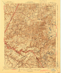
1932 Map of Big Clifty
USGS Topo · Published 1942About this map
Big Clifty serves as a central hub in this western Kentucky landscape, where the Illinois Central Railroad cuts across the terrain near the Rock Crush Asphalt Mine. The 1920s survey work reveals a densely settled rural economy defined by the winding courses of the Rough River and Meeting Creek. Small community anchors are visible throughout, from Calverts Store and Webb Mills to a high concentration of local educational and spiritual centers like Ford High School and Smith Chapel. The map documents a time before significant consolidation, preserving the locations of numerous country schools such as the Colored School and Johnson School. Transportation routes like the Elizabethtown Road and Salt River Road connect these small settlements, reflecting the early 20th-century road network across Grayson County and Hardin County.
Find a feature on this map
74 named features on this map. Tap any name to fly to it.
Don’t see what you’re looking for? This feature index may not catch every label — zoom into the map to look around manually.
Map Details
Editions of this 1932 Big Clifty Map
5 editions found
Other maps of this area

1922 · Leitchfield
USGS Topo · 1:48,000

1925 · Cub Run
USGS Topo · 1:62,500

1925 · Leitchfield
USGS Topo · 1:62,500

1928 · Hardinsburg
USGS Topo · 1:48,000

1931 · Hardinsburg
USGS Topo · 1:62,500

1932 · Big Clifty
USGS Topo · 1:62,500

1934 · Munfordville
USGS Topo · 1:48,000

1935 · Elizabethtown
USGS Topo · 1:48,000

1936 · Vine Grove
USGS Topo · 1:62,500

1937 · Munfordville
USGS Topo · 1:62,500