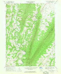
1967 Map of Big Cove Tannery
USGS Topo · Published 1970About this map
Big Cove Tannery and Websters Mill serve as the primary hubs in this corner of Fulton County, where the landscape is defined by the sharp, parallel ridges of Scrub Ridge and Tuscarora Mountain. The settlement pattern follows the narrow valleys, with small communities and family-named landmarks such as The Lockings and Sylvan situated near reliable water sources like Licking Creek and Big Cove Creek. Numerous rural congregations, including St Pauls Ch, Antioch Ch, and Mt Zion Ch, are scattered throughout the townships of Belfast, Ayr, Thompson, and Warren.
Find a feature on this map
46 named features on this map. Tap any name to fly to it.
Don’t see what you’re looking for? This feature index may not catch every label — zoom into the map to look around manually.
Map Details
Editions of this 1967 Big Cove Tannery Map
3 editions found
Other maps of this area

1899 · Hancock
USGS Topo · 1:62,500

1900 · Mercersburg
USGS Topo · 1:62,500

1901 · Hancock
USGS Topo · 1:62,500

1902 · Mercersburg
USGS Topo · 1:62,500

1912 · Williamsport
USGS Topo · 1:62,500

1925 · Needmore
USGS Topo · 1:48,000

1935 · Needmore
USGS Topo · 1:62,500

1939 · Needmore
USGS Topo · 1:62,500

1942 · Hagerstown
USGS Topo · 1:125,000

1943 · Hagerstown
USGS Topo · 1:125,000