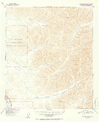
1952 Map of Big Delta C-6
USGS Topo · Published 1952About this map
Eielson Air Force Base dominates the western portion of this interior Alaska landscape, established shortly after the war and depicted here during its early strategic expansion. The topography is defined by the drainage basins of Moose Creek and French Creek, which flow through heavily contoured uplands toward the Tanana River in the southwest corner. The Richardson Highway provides the primary overland artery, following the river corridor near the Little Salcha River confluence. These mid-century surveys were often some of the first systematic records of the region's complex relief, identifying high points such as VABM 2566 Seven and VABM 1831 Canyon that served as critical geodetic control stations for the territory.
Find a feature on this map
12 named features on this map. Tap any name to fly to it.
Don’t see what you’re looking for? This feature index may not catch every label — zoom into the map to look around manually.
Map Details
Editions of this 1952 Big Delta C-6 Map
2 editions found

Other maps of this area

1949 · Fairbanks D-1
USGS Topo · 1:62,500

1949 · Big Delta B-5
USGS Topo · 1:63,360

1949 · Big Delta B-6
USGS Topo · 1:63,360

1949 · Fairbanks C-1
USGS Topo · 1:63,360

1949 · Big Delta C-6
USGS Topo · 1:63,360

1950 · Fairbanks
USGS Topo · 1:250,000

1950 · Big Delta
USGS Topo · 1:250,000

1950 · Big Delta D-6
USGS Topo · 1:63,360

1950 · Fairbanks C-1
USGS Topo · 1:63,360

1950 · Fairbanks B-1
USGS Topo · 1:63,360