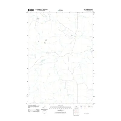
2012 Map of Big Draw
USGS Topo · Published 2012About this map
Stoneville Lake and the branching waters of Sulphur Cr define this ranching landscape in western South Dakota. The terrain is characterized by prominent landmarks like Lookout Butte and Flat Top Butte, which rise above the surrounding drainage basins of Big Draw and Corsaurt Draw. This 2012 survey illustrates the connectivity of this rural area through a network of local roads such as Stoneville Rd and Old Stoneville Rd. Smaller watercourses like Frozen Man Cr and Skirt Cr cut through the plains, revealing the natural hydrology that has likely dictated land use and settlement patterns in this part of Meade County for generations. The map provides clear evidence of how topographic features like Rizer Hill serve as points of orientation in an otherwise open and expansive environment.
Find a feature on this map
14 named features on this map. Tap any name to fly to it.
Don’t see what you’re looking for? This feature index may not catch every label — zoom into the map to look around manually.
Map Details
Editions of this 2012 Big Draw Map
This is the sole edition of this map. No revisions or reprints were ever made.
Other maps of this area

1953 · Rapid City
USGS Topo · 1:250,000

1957 · Rapid City
USGS Topo · 1:250,000

1959 · Fairpoint
USGS Topo · 1:24,000

1959 · Redowl
USGS Topo · 1:24,000

1959 · Stoneville
USGS Topo · 1:24,000

1973 · Frozen Man Creek
USGS Topo · 1:24,000

1978 · Bull Run Creek
USGS Topo · 1:24,000

1983 · Opal West SE
USGS Topo · 1:24,000
1983 · Squaw Buttes
USGS Topo · 1:24,000
1983 · Big Draw
USGS Topo · 1:24,000