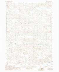
1987 Map of Big Falls
USGS Topo · Published 1988About this map
The North Loup River winds through the heart of this Cherry County landscape, carving a valley defined by the dramatic drop of Big Falls. This 1987 provisional survey illustrates a remote ranching territory where human presence is marked by isolated outposts like Carrier Camp and Wolfenden Ranch. The terrain is crisscrossed by numerous 4wd trails, indicating a reliance on off-road navigation across the undulating Nebraska sandhills. Downstream near the southern boundary, Emmons Ranch sits on the periphery of this sparsely populated river corridor. The map effectively captures the intersection of natural hydrology and the vast grazing lands of the Great Plains, where named features often represent vital water sources or family-held cattle operations during the late twentieth century.
Find a feature on this map
9 named features on this map. Tap any name to fly to it.
Don’t see what you’re looking for? This feature index may not catch every label — zoom into the map to look around manually.
Map Details
Editions of this 1987 Big Falls Map
This is the sole edition of this map. No revisions or reprints were ever made.
Other maps of this area

1949 · Big Falls
USGS Topo · 1:62,500

1950 · Powderhorn Valley
USGS Topo · 1:62,500

1950 · Doughboy
USGS Topo · 1:62,500

1950 · Wolf Lake
USGS Topo · 1:62,500

1951 · Big Falls
USGS Topo · 1:62,500

1951 · Wolf Lake
USGS Topo · 1:62,500

1952 · Doughboy
USGS Topo · 1:62,500

1957 · Valentine
USGS Topo · 1:250,000

1959 · Valentine
USGS Topo · 1:250,000

1985 · Powderhorn Valley SW
USGS Topo · 1:24,000