
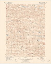
1951 Map of Big Falls
USGS Topo · Published 1951About this map
The North Loup River winds through this section of Cherry County, marked by natural landmarks like Big Falls and Horseshoe Falls. This mid-century landscape is defined by its extensive ranching history, with numerous family-named properties such as Wolfenden Ranch, Boyer Ranch, and the Cloyed Carpenter Ranch scattered across the Gillaspie and Fern regions. The map reveals a remote but established rural infrastructure, evidenced by localized centers of education like Starr Sch and Dry Valley Sch.
Find a feature on this map
50 named features on this map. Tap any name to fly to it.
Don’t see what you’re looking for? This feature index may not catch every label — zoom into the map to look around manually.
Map Details
Editions of this 1951 Big Falls Map
2 editions found
Other maps of this area

1948 · Seneca
USGS Topo · 1:62,500

1948 · Mullen
USGS Topo · 1:62,500

1949 · Big Falls
USGS Topo · 1:62,500

1950 · Hire
USGS Topo · 1:62,500

1950 · Powderhorn Valley
USGS Topo · 1:62,500

1950 · Kennedy
USGS Topo · 1:62,500

1950 · Doughboy
USGS Topo · 1:62,500

1950 · Wolf Lake
USGS Topo · 1:62,500

1951 · Mullen
USGS Topo · 1:62,500

1951 · Seneca
USGS Topo · 1:62,500