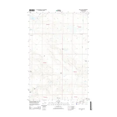
2014 Map of Big Flat East
USGS Topo · Published 2014About this map
Big Flat and its intricate network of seasonal drainages define this portion of the Lodge Pole District as documented in the early 2010s. The landscape is marked by several prominent coulees, including Chicken Coulee, Tressler Coulee, and Sage Hen Coulee, which serve as natural landmarks across the high plains. Water management is evident in the northwest corner with Weigand Reservoir, while Wild Horse Cr and Mud Cr wind through the township boundaries.
Find a feature on this map
18 named features on this map. Tap any name to fly to it.
Don’t see what you’re looking for? This feature index may not catch every label — zoom into the map to look around manually.
Map Details
Editions of this 2014 Big Flat East Map
This is the sole edition of this map. No revisions or reprints were ever made.
Other maps of this area

1953 · Havre
USGS Topo · 1:250,000

1957 · Havre
USGS Topo · 1:250,000

1958 · Havre
USGS Topo · 1:250,000

1964 · Coburg SE
USGS Topo · 1:24,000

1964 · Weigand Reservoir
USGS Topo · 1:24,000

1964 · Cow Creek
USGS Topo · 1:24,000

1965 · Phillips
USGS Topo · 1:24,000

1965 · Wild Horse Reservoir
USGS Topo · 1:24,000

1971 · Big Flat East
USGS Topo · 1:24,000
1971 · Ball Coulee
USGS Topo · 1:24,000