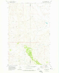
1971 Map of Ball Coulee
USGS Topo · Published 1975About this map
The Judith River flows through the southern reaches of this landscape, carving through a region defined by the Ridge and deep coulees within the Fort Belknap Indian Reservation. This 1971 field-checked survey reveals a quiet, dispersed settlement pattern marked by several small family or community burial grounds, including Messerly Cem and Kirkaldie Cem. The terrain is characterized by seasonal drainage systems such as Lone Tree Coulee and Ball Coulee, which channel water toward larger bodies like the Government Field Reservoir. Further south, Chopwood Cem and Big Warm Cem sit near the banks of Big Warm Creek, providing specific points of interest for genealogists tracing local history along the border of Phillips and Blaine counties. The map effectively documents the transition from open range to localized landmarks along the river breaks.
Find a feature on this map
14 named features on this map. Tap any name to fly to it.
Don’t see what you’re looking for? This feature index may not catch every label — zoom into the map to look around manually.
Map Details
Editions of this 1971 Ball Coulee Map
This is the sole edition of this map. No revisions or reprints were ever made.
Other maps of this area

1943 · Landusky
USGS Topo · 1:125,000

1953 · Havre
USGS Topo · 1:250,000

1954 · Lewistown
USGS Topo · 1:250,000

1957 · Havre
USGS Topo · 1:250,000

1958 · Havre
USGS Topo · 1:250,000

1959 · Lewistown
USGS Topo · 1:250,000

1971 · Big Flat East
USGS Topo · 1:24,000

1971 · Bear Mountain
USGS Topo · 1:24,000

1971 · Lodge Pole NE
USGS Topo · 1:24,000
1971 · Lodge Pole
USGS Topo · 1:24,000