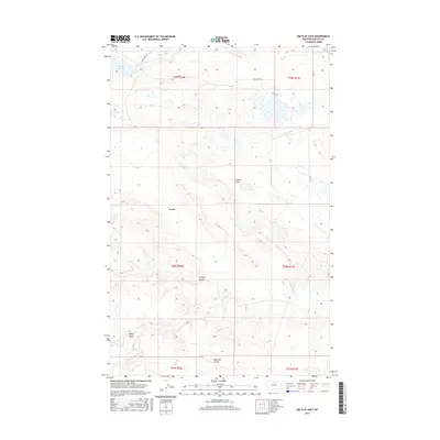
2017 Map of Big Flat East
USGS Topo · Published 2017About this map
Big Flat dominates the landscape of this Phillips County region, a high prairie expanse carved by a network of drainage channels. The northern reach is defined by the Weigand Reservoir and the headwaters of Mud Creek, while the southern terrain is marked by the winding courses of Wild Horse Creek and several distinct geological depressions. The naming of these features, including Tressler Coulee, Chicken Coulee, and Sage Hen Coulee, reflects the local wildlife and pioneer-era topography of this high plains district. Transportation is sparse, anchored by the north-south corridor of Hwy 204 and the evocative Stage Coach Rd, which traces a historic path across the northern townships. The map provides a detailed view of the Public Land Survey System divisions, from T29N R26E down to T27N R27E, illustrating the systematic grid of section lines that organized this remote grazing and ranching territory.
Find a feature on this map
16 named features on this map. Tap any name to fly to it.
Don’t see what you’re looking for? This feature index may not catch every label — zoom into the map to look around manually.
Map Details
Editions of this 2017 Big Flat East Map
This is the sole edition of this map. No revisions or reprints were ever made.
Other maps of this area

1953 · Havre
USGS Topo · 1:250,000

1957 · Havre
USGS Topo · 1:250,000

1958 · Havre
USGS Topo · 1:250,000

1964 · Coburg SE
USGS Topo · 1:24,000

1964 · Weigand Reservoir
USGS Topo · 1:24,000

1964 · Cow Creek
USGS Topo · 1:24,000

1965 · Phillips
USGS Topo · 1:24,000

1965 · Wild Horse Reservoir
USGS Topo · 1:24,000

1971 · Big Flat East
USGS Topo · 1:24,000
1971 · Ball Coulee
USGS Topo · 1:24,000