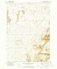
1972 Map of Big Grassy Ridge
USGS Topo · Published 1976About this map
Big Grassy Ridge dominates this 1970s landscape in Fremont County, where volcanic activity and wind-blown deposits have shaped a distinct high-desert environment. The topography reveals a prominent Crater at the ridge summit and expansive fields of Sand Dunes that shift across the northern and southeastern sections of the quadrangle. Human activity in this arid region is tied closely to the few available water sources, notably Sandy Butte Well and Jenkins Well, which support livestock in an otherwise dry expanse. Transport relies on a network of rugged paths, including the primary Red Road and numerous unnamed Jeep Trails that snake through the North Junipers and South Junipers. This survey provides a clear view of the complex terrain at West Butte and within Hansen Basin, capturing the area as it functioned before modern shifts in land use or intensive development.
Find a feature on this map
12 named features on this map. Tap any name to fly to it.
Don’t see what you’re looking for? This feature index may not catch every label — zoom into the map to look around manually.
Map Details
Editions of this 1972 Big Grassy Ridge Map
This is the sole edition of this map. No revisions or reprints were ever made.
Other maps of this area

1948 · Parker
USGS Topo · 1:24,000

1950 · Parker
USGS Topo · 1:24,000

1951 · Plano
USGS Topo · 1:24,000

1955 · Dubois
USGS Topo · 1:250,000

1955 · Idaho Falls
USGS Topo · 1:250,000

1955 · Ashton
USGS Topo · 1:250,000

1955 · Driggs
USGS Topo · 1:250,000

1958 · Driggs
USGS Topo · 1:250,000

1958 · Dubois
USGS Topo · 1:250,000

1958 · Idaho Falls
USGS Topo · 1:250,000