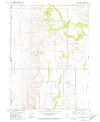
1980 Map of Big Hat Mtn
USGS Topo · Published 1980About this map
Big Hat Mountain dominates this high-desert terrain along the border of Nevada and California, providing a detailed look at the water sources and primitive routes essential to the area's ranching history. The map highlights the reliance on isolated water points like Dip Spring and Roe Deer Spring, while the presence of Long Ranch in Surprise Valley indicates the persistent footprint of livestock operations in this arid environment.
Find a feature on this map
31 named features on this map. Tap any name to fly to it.
Don’t see what you’re looking for? This feature index may not catch every label — zoom into the map to look around manually.
Map Details
Editions of this 1980 Big Hat Mtn Map
2 editions found
Other maps of this area

1886 · Alturas
USGS Topo · 1:250,000

1889 · Long Valley
USGS Topo · 1:250,000

1892 · Alturas
USGS Topo · 1:250,000

1954 · Vya
USGS Topo · 1:250,000

1954 · Alturas
USGS Topo · 1:250,000

1958 · Alturas
USGS Topo · 1:250,000

1958 · Vya
USGS Topo · 1:250,000

1962 · Alturas
USGS Topo · 1:250,000

1962 · Vya
USGS Topo · 1:250,000

1962 · Cedarville
USGS Topo · 1:62,500