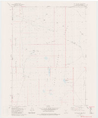
1980 Map of Big Hat Mtn.
USGS Topo · Published 1980About this map
The high desert landscape along the California-Nevada border is defined by the Hays Range and the eastern edge of Surprise Valley. Mapped in the 1970s, this area reflects a remote ranching and grazing environment where water sources are the primary landmarks. Long Ranch stands as a focal point of settlement near Big Spring, while the surrounding terrain is marked by volcanic and erosional features such as The Craters and Table Lakes, which includes the small Long Lake.
Find a feature on this map
30 named features on this map. Tap any name to fly to it.
Don’t see what you’re looking for? This feature index may not catch every label — zoom into the map to look around manually.
Map Details
Editions of this 1980 Big Hat Mtn. Map
2 editions found
Other maps of this area

1886 · Alturas
USGS Topo · 1:250,000

1889 · Long Valley
USGS Topo · 1:250,000

1892 · Alturas
USGS Topo · 1:250,000

1954 · Vya
USGS Topo · 1:250,000

1954 · Alturas
USGS Topo · 1:250,000

1958 · Alturas
USGS Topo · 1:250,000

1958 · Vya
USGS Topo · 1:250,000

1962 · Alturas
USGS Topo · 1:250,000

1962 · Vya
USGS Topo · 1:250,000

1962 · Cedarville
USGS Topo · 1:62,500