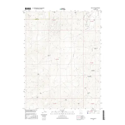
2017 Map of Big Hollow
USGS Topo · Published 2017About this map
Pollys Peak stands as a prominent landmark overlooking the complex drainage systems of Juab and Sanpete counties in central Utah. The landscape is defined by its numerous eponymous "hollows" and washes, carving through the high-elevation terrain to reveal a network of seasonal water sources. Features such as Water Hollow, Serviceberry Hollow, and Cottonwood Spring Hollow indicate a terrain where water management and natural springs, like House Spring and Whitaker Springs, have historically dictated land use and movement.
Find a feature on this map
33 named features on this map. Tap any name to fly to it.
Don’t see what you’re looking for? This feature index may not catch every label — zoom into the map to look around manually.
Map Details
Editions of this 2017 Big Hollow Map
This is the sole edition of this map. No revisions or reprints were ever made.
Other maps of this area

1885 · Manti
USGS Topo · 1:250,000

1895 · Manti
USGS Topo · 1:250,000

1951 · Moroni
USGS Topo · 1:62,500

1952 · Santaquin Peak
USGS Topo · 1:62,500

1956 · Price
USGS Topo · 1:250,000

1960 · Price
USGS Topo · 1:250,000

1962 · Price
USGS Topo · 1:250,000
1967 · Indianola
USGS Topo · 1:24,000
1967 · Mount Pleasant
USGS Topo · 1:24,000
1967 · Fairview
USGS Topo · 1:24,000