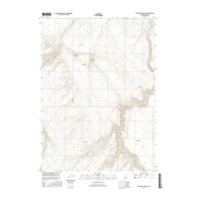
2017 Map of Big Horse Basin Gap
USGS Topo · Published 2017About this map
Big Horse Basin Gap and Little Horse Basin Gap define the high-elevation passage through this segment of Owyhee County. The landscape is characterized by the intricate drainage systems of Big Jacks Cr and Little Jacks Cr, which carve deep, winding paths through the terrain. These natural corridors and the broader Horse Basin provided essential navigation points for travelers and ranchers in a region defined by its complex hydrologic network, including Rattlesnake Cr in the southwest. The map documents the precise topography of the Public Land Survey System, showing the intersections of Township 8 and 9 South with Ranges 3 and 4 East, illustrating how the vast open spaces of southwestern Idaho are partitioned for land management and resource use.
Find a feature on this map
10 named features on this map. Tap any name to fly to it.
Don’t see what you’re looking for? This feature index may not catch every label — zoom into the map to look around manually.
Map Details
Editions of this 2017 Big Horse Basin Gap Map
This is the sole edition of this map. No revisions or reprints were ever made.
Other maps of this area

1947 · Little Valley
USGS Topo · 1:24,000

1947 · Grand View
USGS Topo · 1:62,500

1947 · Bruneau
USGS Topo · 1:62,500

1947 · Chalk Hills
USGS Topo · 1:24,000

1947 · Perjue Canyon
USGS Topo · 1:24,000

1948 · Perjue Canyon
USGS Topo · 1:24,000
1948 · Little Valley
USGS Topo · 1:24,000
1948 · Chalk Hills
USGS Topo · 1:24,000

1955 · Jordan Valley
USGS Topo · 1:250,000

1955 · Twin Falls
USGS Topo · 1:250,000