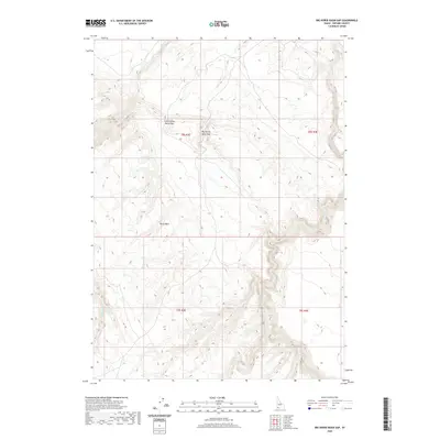
2020 Map of Big Horse Basin Gap
USGS Topo · Published 2020About this map
Big Horse Basin Gap and its neighbor, Little Horse Basin Gap, form critical topographic breaks in the high desert landscape of Owyhee County. This 2020 survey illustrates a complex network of seasonal drainage and steep rimrock terrain, where Horse Basin sits as a prominent natural depression. The hydrology of the region is defined by the deep incisions of Big Jacks Cr and Little Jacks Cr, which carve through the volcanic plateau. These watercourses, along with Rattlesnake Cr, dictate the movement of both wildlife and land use in a territory largely defined by the Public Land Survey System. The map provides a precise view of the section lines and township boundaries, including t8s r3e and t9s r4e, which are essential for property research and understanding the historical administration of this arid backcountry.
Find a feature on this map
10 named features on this map. Tap any name to fly to it.
Don’t see what you’re looking for? This feature index may not catch every label — zoom into the map to look around manually.
Map Details
Editions of this 2020 Big Horse Basin Gap Map
This is the sole edition of this map. No revisions or reprints were ever made.
Other maps of this area

1947 · Little Valley
USGS Topo · 1:24,000

1947 · Grand View
USGS Topo · 1:62,500

1947 · Bruneau
USGS Topo · 1:62,500

1947 · Chalk Hills
USGS Topo · 1:24,000

1947 · Perjue Canyon
USGS Topo · 1:24,000

1948 · Perjue Canyon
USGS Topo · 1:24,000
1948 · Little Valley
USGS Topo · 1:24,000
1948 · Chalk Hills
USGS Topo · 1:24,000

1955 · Jordan Valley
USGS Topo · 1:250,000

1955 · Twin Falls
USGS Topo · 1:250,000